Hunter Regional Plan
The Hunter Regional Plan 2041 was prepared by the NSW Department of Planning and Environment (NSW DP&E). It is a regional land use strategy that applies to the Local Government Areas (LGA’s) within the Hunter Region, which includes the Singleton LGA. It aims to provide the overarching framework to guide the NSW Government’s land use planning priorities and decisions to 2041.
The Hunter Regional Plan 2041 updates the strategic framework for the region, to ensure the region’s ongoing prosperity. The Hunter Regional Plan 2041 builds on the previous plan which was finalised in October 2016. Since then, the NSW Government has worked closely with local councils, other stakeholders and the community to deliver on the plan’s key priority actions.
It is a 20-year land use plan focusing on the next 5 years and is prepared in accordance with section 3.3 of the Environmental Planning and Assessment Act 1979. It applies to the local government areas of Cessnock, Lake Macquarie, Maitland, Newcastle, Port Stephens, Muswellbrook, Singleton, Upper Hunter, MidCoast and Dungog.
The Hunter is the leading regional economy in Australia, accommodating 427,000 jobs. It is home to one of Australia’s most productive wine regions and a significant equine industry around Scone. The traditional mining, energy and manufacturing sectors present opportunities to transform to cleaner, renewable energy sources. The Hunter’s population of 860,000 people is expected to increase to nearly 950,000 people by 2041. This requires us to plan for an additional 101,800 dwellings across the region.
The Hunter Regional Plan 2041 recognises the region is changing. It draws on the concepts of sequenced planning and infrastructure, creating great places and enriching community character.
The plan is about sustainable growth. It looks at housing choice and lifestyle opportunities to cement the Hunter as a leading regional economy.
What is the regional plan and why has it been reviewed?
In 2016 the then Department of Planning and Environment finalised the Hunter Regional Plan 2036 which was the first regional plan for the region and one of 9 prepared to cover all NSW regions outside Greater Sydney for the first time.
Regional plans set out a 20-year vision for the region and the direction to achieve it by responding to the existing and future community needs for housing, jobs, infrastructure, a healthy environment, connected communities and access to green spaces. Regional plans also guide planning and investment decisions by State and local government and the private sector.
The existing regional plan includes a commitment for its regular review. The review provides an opportunity to consider the changes in the last five years that affect the region, the challenges and opportunities ahead, and update the plan to respond.
What is the Hunter Regional Plan 2041?
The Hunter Regional Plan 2041 updates the strategic framework for the region, to ensure the region’s ongoing prosperity.
The Hunter Regional Plan 2041 builds on the previous plan which was finalised in October 2016. Since then, the NSW Government has worked closely with local councils, other stakeholders and the community to deliver on the plan’s key priority actions.
It is a 20-year land use plan focusing on the next 5 years and is prepared in accordance with section 3.3 of the Environmental Planning and Assessment Act 1979. It applies to the local government areas of Cessnock, Lake Macquarie, Maitland, Newcastle, Port Stephens, Muswellbrook, Singleton, Upper Hunter, MidCoast and Dungog.
What has the current plan helped deliver?
Since the Hunter Regional Plan 2036 was released, the NSW Government has worked closely with local councils, other stakeholders and the community to deliver on key priority actions to improve the region for residents and visitors including:
- The Greater Newcastle Metropolitan Plan 2036 and implementation of catalyst areas.
- A memorandum of understanding with the Hunter Joint Organisation on implementation of the Greater Newcastle Metropolitan Plan 2036.
- Exhibition of a draft Hunter Expressway Strategy.
- Establishment of the Greater Newcastle Urban Development Program.
What are the key ideas in the Hunter Regional Plan 2041?
The plan is focused on making great places with more everyday uses close to home, supported by the right sequencing of development and infrastructure to ensure sustainable growth. The department will collaborate with each local council on the regionally significant places across the Hunter. These places will help to meet the plan’s vision and objectives in the shortest possible time.
The plan contains the following new big ideas to support the delivery of the vision:
- Greater diversification of employment, mining and energy generation lands to support economic renewal and innovation and create opportunities for renewal and change to new land uses.
- A new approach and energy to how we sequence planning for new land uses and infrastructure to accelerate proposals that will support the vision and bring even greater public value.
- New pathways to promote economic self-determination, more meaningfully recognise and respect Traditional Custodians, create true connections to Country and integrate Aboriginal cultural knowledge and practice into urban design and planning.
- Introducing net zero emissions as a guiding principle for all planning decisions.
- Embedding resilience in planning and design decisions to improve responses to chronic stresses and acute shocks.
- A focus on 15-minute mixed-use neighbourhoods where most needs can be met within a 15-minute walk, bike ride, or drive for people in rural areas.
- A preference for infill development rather than greenfield development, where we plan for housing densities that align with how a neighbourhood functions and the type of public transport available, and establish flexible land uses to allow communities to evolve.
- A renewed focus on green infrastructure, public spaces and nature, using planning decisions to reinforce, enhance and improve quality of life.
- Better access to and networks of walking, cycling and public transport in urban areas, towns and villages.
- A greater focus on equity, meaning that people have greater choice in where and how they live, how they travel and where and how they work.
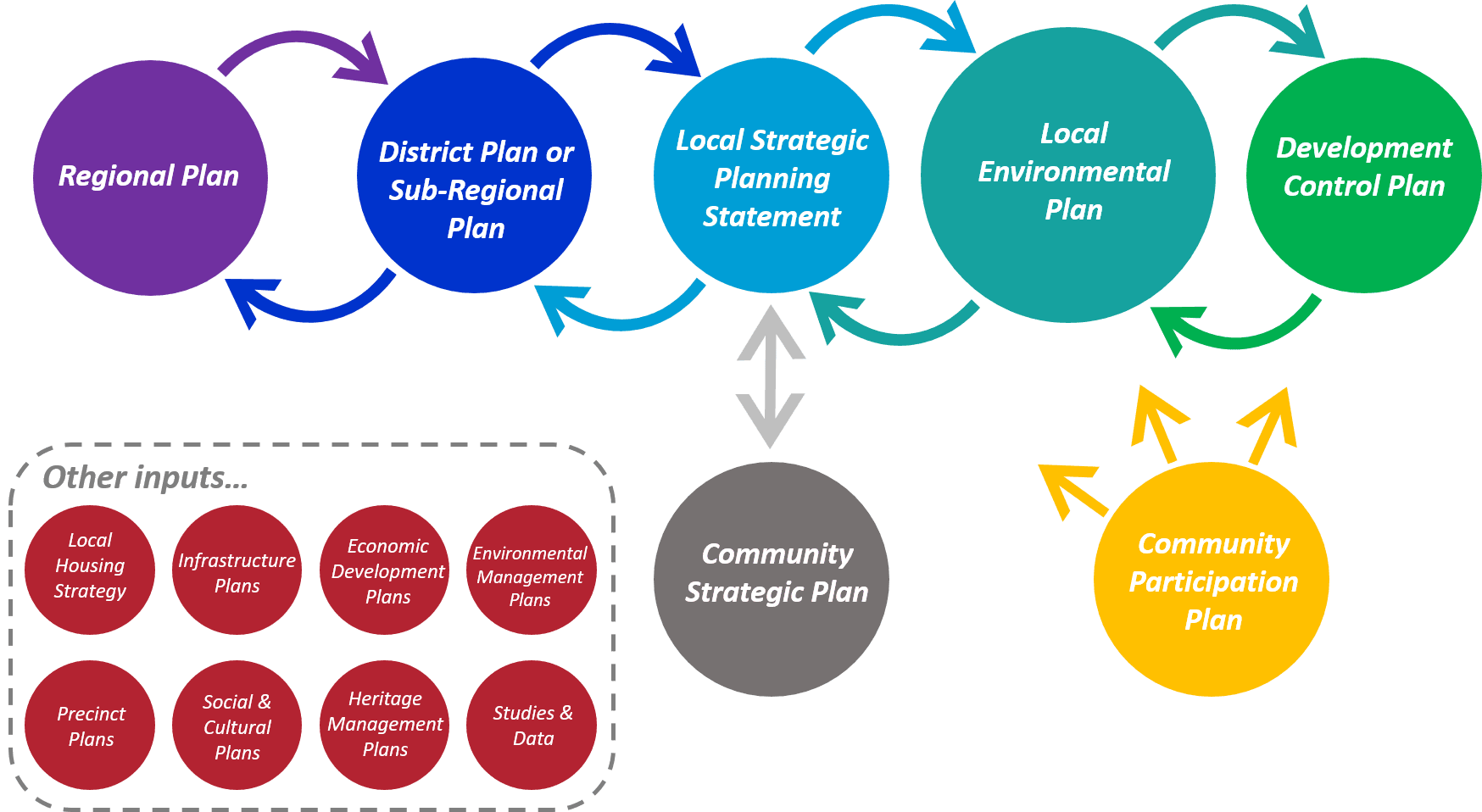
How does the Hunter Regional Plan 2041 fit in with councils’ local strategic planning statements?
By 1 July 2020, all councils in NSW were required to prepare a local strategic planning statement (LSPS) setting out the 20-year vision for land use in the local area, the special character and values that are to be preserved and how change will be managed into the future. All councils in the region prepared LSPSs for their respective local government areas.
The plan’s approach of setting the outcomes really empowers local decision making by councils. The new plan makes local strategic planning the foundation of working with local communities on growth in line with the clear outcomes in the plan.
LSPSs have given the councils the opportunity to:
- Ensure the priorities identified in the regional plan are placed within a clear local context and tailored to the unique economic, social and environmental characteristics of their local government area.
- Translate the vision and directions of their community strategic plan and their own strategic planning work into local priorities and actions.
- Inform the review of the regional plan.
To ensure this strong link between the two planning levels continues, the Hunter Regional Plan 2041 will inform future reviews of the LSPS.
How does the Department of Planning and Environment’s population projections relate to the Hunter Regional Plan 2041?
The NSW Government regularly reviews population projections to be able to understand and respond to unexpected events such as the COVID-19 pandemic, responding to drought, floods and catastrophic bushfire events. New population projections were prepared in 2022 and will be prepared again in 2023 when it will incorporate the full suite of 2021 Census data that will then be available.
The regional plan is focused on achieving great outcomes from future growth of the Hunter, such as 15-minute mixed use neighbourhoods. These can be applied in areas that may experience a little growth, such as rural villages, or in high growth areas.
Is there any investment coming to the region?
A key component of the plan is an infrastructure-first and place-based approach to materialise the plan’s vision and objectives into outcomes for the community. It is a new process that will deliver great places by identifying and prioritising infrastructure investment upfront when we plan for growth.
At present, strategic land-use decisions, including those relating to State infrastructure contributions, often precede capital investment planning by infrastructure and service delivery authorities. Consequently, decisions on infrastructure investment often lag behind the identification and development of new growth areas and increased housing in existing places.
An infrastructure-first, place-focused approach to development planning requires infrastructure providers, the development industry and public authorities to take an integrated and coherent place-based approach to land use planning. This strategic and collaborative approach to infrastructure investment will achieve better outcomes for communities, industry and government.
What does the Hunter Regional Plan 2041 say about mining?
The plan includes strategies to help transition the region’s major coal mining industry to a renewable and cleaner energy future which will be a major drawcard for jobs and investment as NSW moves towards net zero emissions.
It explores opportunities across the region to transform rehabilitated mines and decommissioned power stations into renewable energy hubs and industrial manufacturing facilities using their existing infrastructure. The focus is on promoting employment in new industries.
What’s in it for my council?
The plan divides the Hunter into six districts that each share similar characteristics, such as economic and infrastructure, geography and settlement patterns, housing markets, community expectation and levels of self-containment.
The plan acknowledges common planning interests with councils, without duplicating all aspects of land use planning. Rather than dictate additional actions for councils, the plan identifies the objectives and principles that councils will apply during local strategic planning or when considering development proposals.
The Department of Planning and Environment and each local council will work together on each district’s planning priorities, including local planning responses that sequence both planning and investment.